
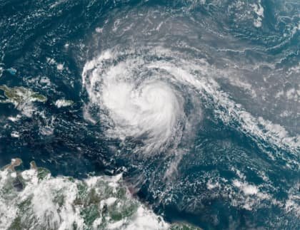
The first major hurricane of the 2025 Atlantic season, Hurricane Erin which is rapidly gaining strength and is currently forming above the central Atlantic region with powerful winds and as estimated by the meteorologists has successfully reached category 4 strength and intensity with an even broader reach.
Till yesterday it was considered as a tropical storm sustaining wind speeds of nearly 70mph, but as of Saturday morning (today) , Erin has already given the threat of category 3 hurricane as winds could reach a speed of nearly 100mph. Because the conditions remained favourable for Erin it has now reached Category 4 strength within just 2 days.
While the storm is remaining offshore, the rain showers are spreading across the Southern US and the Caribbean Region. The regions are expected with tropical storm force gusts, heavy downpours and dangerous surf.
Erin is currently following the west-northwest path and is expected to cross the northern areas of Leeward Islands, including the Virgin Islands and Puerto Rico.
As predicted, rainfalls can total up to six inches triggering flash flood warnings and mudslides. Even when the hurricane is not having a direct hit with the areas.
The Government and emergency services of the high alerted areas have urged the public to stay alert and updated especially the residents in the low-lying coastal areas are urged to follow the local emergency updates.
As per the meteorologists, seeing the conditions earlier in the next week Erin is expected to turn towards the North, affecting areas between Bermuda, Bahamas and the US mainland additionally it can cause rip currents, high surfs and coastal erosion in areas of Florida and New England.
The Bahamas and Turks and Caicos are at high risk, the centre of the forecast remains to the east but if because of the conditions it somehow turned a little towards the west it can cause major impacts in Bermuda.
Erin is a massive reminder of how fast the tropical storms can turn into a higher category hurricane in peak hurricane season, and even the islands are not in a direct trajectory but still they will be facing major effects.
Officials across the Caribbean region and along the US east coast have sincerely urged the residents and the visitors of those regions to stay alert and follow the local emergency protocols if needed as the storm is continuing to intensify.